Specialized surveying has become a key tool for infrastructure, urban development, construction, agriculture, energy, and land-use planning projects. On large-scale projects, accurate terrain data supports better decisions from the earliest stages, reduces technical uncertainty, and streamlines design and execution.
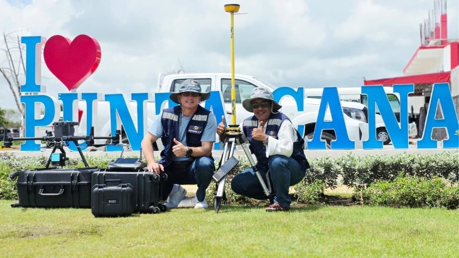
In Punta Cana, Dominican Republic, SECONPA carried out a topographic survey using LiDAR and GPS technology over an area of approximately 1,200 hectares (about 3,000 acres) in the Las Lagunas de Nisibón area, providing high-value geospatial data for project planning.
This article is part of our technology and innovation content for construction, where we highlight digital solutions, technical tools, and methods that are transforming how projects are planned, designed, and built.
The project was carried out by SECONPA, a company specializing in surveying, LiDAR, ground-penetrating radar, bathymetry, photogrammetry, cadastral surveys, construction control, and geospatial solutions for technical projects.
You can also find more industry projects and content in the ConstructHUBS digital magazine, or visit SECONPA’s official website.
A large-scale topographic survey in Punta Cana
The survey in Punta Cana covered approximately 1,200 hectares, a scale that requires technical planning, the right equipment, and a methodology capable of capturing accurate data across a large and varied area.
On projects like this, traditional surveying can require long field times, especially where there are large areas, vegetation, elevation changes, internal roads, wetlands, or hard-to-reach locations.
Combining LiDAR and GPS technology yields high-density, high-accuracy data, making it easier to produce terrain models, contour lines, slope analyses, and technical deliverables useful to engineering, architecture, planning, and development teams.
What is LiDAR technology in surveying?
LiDAR is a remote sensing technology that uses laser pulses to capture three-dimensional data of the terrain and the features on its surface. Combined with positioning systems and specialized processing, it produces highly detailed point clouds.
In surveying, this technology is especially useful because it records large amounts of data in less time than some conventional methods while maintaining a high level of technical accuracy.
The resulting point cloud can be used to create digital terrain models, digital surface models, topographic maps, profiles, cross sections, volumetric analyses, and other deliverables needed for project planning and design.
The role of GPS in survey accuracy
Using GPS in topographic surveys georeferences the captured data and ensures it is correctly positioned in space.
On large projects, geospatial accuracy is essential. Capturing terrain data is not enough; that data must be tied to reliable coordinates so it can be used by the different technical teams involved.
Combining LiDAR and GPS brings together capture speed, accuracy, and traceability, creating a solid technical foundation for decision-making.
Advantages of combining LiDAR and GPS on land development projects
Combining LiDAR and GPS offers important advantages for projects that require detailed terrain data. Key benefits include shorter capture times, the ability to cover large areas, three-dimensional models, and data useful to multiple disciplines.
This methodology makes it possible to analyze slopes, access routes, natural drainage, intervention areas, vegetation, elevations, grade changes, and overall site conditions.
For developers, designers, and engineers, having this information from the start can improve planning, reduce later changes, and make coordination between project phases easier.
Technical data for planning and design
A topographic survey is not just a representation of the terrain. It is a working tool for understanding actual site conditions and anticipating design decisions.
On large-scale projects, survey data can influence the location of infrastructure, road alignments, building pads, drainage, earthwork, green spaces, buildings, access points, and conservation areas.
When this data is captured accurately, technical teams can work from a more reliable base and reduce uncertainty in later stages.
Applications in construction, infrastructure, and urban development
LiDAR and GPS surveys have many applications in construction and infrastructure. They can be used for urban developments, roads, tourism projects, water works, transmission lines, agricultural projects, industrial parks, large-scale buildings, and preliminary site studies.
They are also useful for progress monitoring, updating existing data, volumetric analysis, accessibility studies, earthwork planning, and producing technical documentation for design.
In fast-growing areas such as Punta Cana, this type of technology can bring greater clarity to planning projects in a more orderly, efficient, and technically sound way.
Reducing uncertainty in the early stages
One of the main benefits of an accurate topographic survey is reduced uncertainty. Before designing, budgeting, or building, you need to know the terrain in as much detail as possible.
A lack of information can lead to design changes, field adjustments, cost overruns, and delays. A reliable survey base, on the other hand, makes it possible to anticipate risks, identify constraints, and develop more realistic proposals.
On large projects, this data becomes a strategic input for technical and business decisions.
SECONPA and specialized surveying for large-scale projects
SECONPA’s involvement in this survey shows the value of working with companies that specialize in advanced surveying solutions. Technology alone does not guarantee results; it also takes technical experience, methodology, quality control, and the ability to interpret the data.
Services such as LiDAR, GPS, GPR, photogrammetry, bathymetry, and construction control add value when they are aligned with each project’s real needs and delivered in formats that design, engineering, and construction teams can use.
In that sense, specialized surveying becomes a key tool for projects that require accuracy, speed, and better management of land data.
Conclusion: accurate data for better decisions
The LiDAR and GPS topographic survey carried out in Punta Cana shows how geospatial technology can add value from the earliest stages of a project.
Covering approximately 1,200 hectares, this work produced accurate technical data to better understand the terrain, support planning, and strengthen decision-making.
At ConstructHUBS, we continue to highlight projects, companies, and technologies that drive more accurate and innovative construction, connected to the real needs of each site.