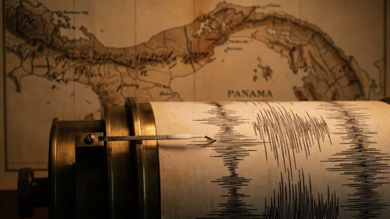
Panama’s fault lines number in the dozens. The map of Quaternary faults and folds by the U.S. Geological Survey (USGS) and the Institute of Geosciences at the University of Panama catalogs 22 main structures, divided into more than 40 sections, and later studies have identified others, such as the Pedro Miguel Fault. The most active are the Panama Fracture Zone, in Chiriquí, and the North Panama Deformed Belt, in the Caribbean.
Knowing Panama’s fault lines helps explain why some regions shake more than others and what precautions each area requires when building. In this article, we explain how many there are, where they are, which are the most active, and which earthquakes are associated with each one.
How many fault lines are there in Panama?
There is no single figure, because it depends on the scale of the study and on what counts as an independent fault. The most complete reference is the map of Quaternary faults and folds of Panama, published in 1998:
- 22 main structures, numbered PA-01 to PA-22, including faults, fault zones, deformed belts, and folds.
- More than 40 sections if you count the segments each structure is divided into.
- Faults added later: the Pedro Miguel Fault, next to the Canal, does not appear by name on that map. It was confirmed as active by the studies for the Canal expansion, published in 2010.
Many of Panama’s fault lines lie under the sea, off the Pacific and Caribbean coasts, while others cross Chiriquí, Azuero, Central Panama, and Darién.
Why does Panama have so many faults?
The isthmus sits on the Panama microplate, a block of crust trapped between four moving plates: the Caribbean Plate to the north, the Cocos Plate to the southwest, the Nazca Plate to the south, and the South American Plate to the east. That constant collision deforms the crust and breaks it into faults, both along the edges of the block and within it.
That is why the country records around 500 earthquakes a year, according to the Institute of Geosciences, although most are not felt.
Panama’s main fault lines
1. Panama Fracture Zone (Chiriquí)
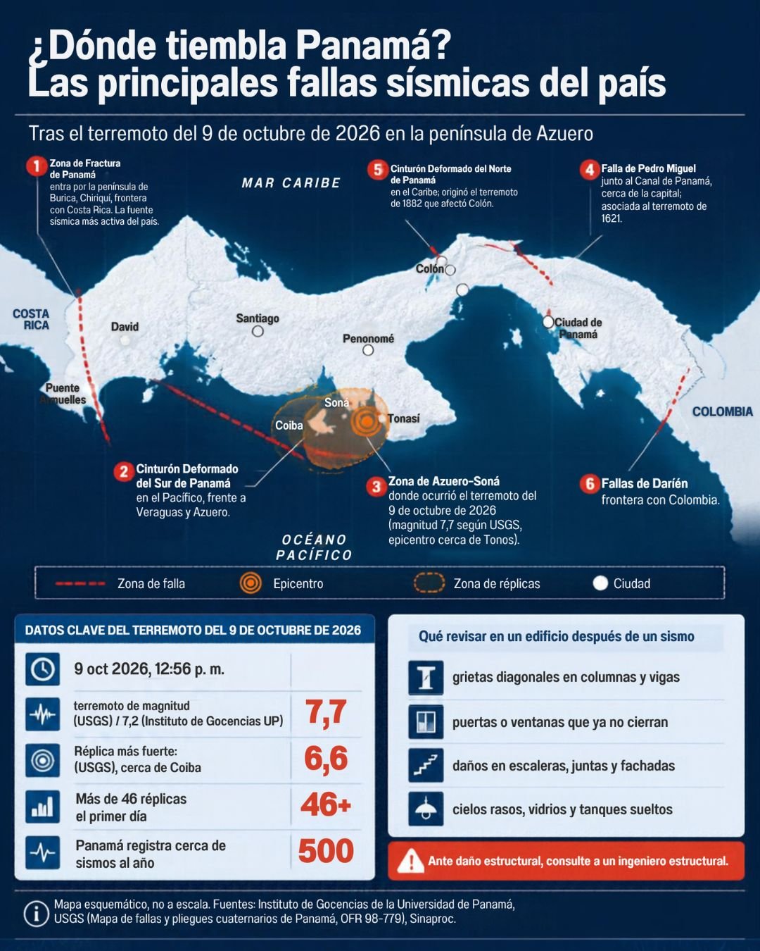
This is the boundary between the Cocos and Nazca plates. It extends more than 400 km (250 miles) along the Pacific seafloor and reaches land at the Burica Peninsula, on the border with Costa Rica. It is the most active seismic source in the country and the structure with the highest slip rate on the USGS map, probably more than 5 mm per year. The Puerto Armuelles earthquakes of 1934, 2002, 2003, and 2019 are associated with it.
2. Coiba and Balboa fracture zones (Pacific off Veraguas)
These are undersea extensions of the Panama Fracture Zone, south of Veraguas and around Coiba Island. Several of the strongest aftershocks of the 2026 Azuero earthquake were concentrated in this area.
3. South Panama Deformed Belt (Pacific)
A strip of folded and faulted crust on the Pacific seafloor, off Veraguas and the Azuero Peninsula, where the Nazca Plate pushes against the Panama block.
4. Azuero–Soná fault zone and the Azuero faults
It crosses the Azuero Peninsula and the Soná area. The USGS map also records the Río Flores fault zone and other unnamed faults in Azuero. This is the region where the October 9, 2026, Azuero earthquake occurred, the strongest ever measured with instruments in the country. Scientists are still studying which specific fault ruptured.
5. North Panama Deformed Belt (Caribbean)
It runs along the Caribbean seafloor off Bocas del Toro, Colón, and Guna Yala, where the Caribbean Plate slowly sinks beneath the Panama block. It was the source of the 1882 earthquake, with an estimated magnitude of 7.9, which generated a tsunami in San Blas. Its large earthquakes tend to produce local tsunamis, and historical studies also attribute strong events in 1873, 1909, and 1930 to it.
6. Central Panama faults: Pedro Miguel, Limón, and Río Gatún
These are the faults closest to the capital and the Canal:
- Pedro Miguel Fault: it runs north to south alongside the Canal and is believed to have caused the 1621 earthquake that damaged Panamá Viejo.
- Limón Fault: north of the Pedro Miguel Fault, in Colón. It moves about 6 mm per year and, together with Pedro Miguel, could generate an earthquake of magnitude 7 or greater.
- Río Gatún Fault: near Colón. It had a surface rupture around 1670 and moves about 3 mm per year.
7. East Panama Deformed Belt and the Darién faults
In the east of the country, the USGS map records the Cerro Sansón, Pirre, and Sambú fault zones and the Río Jaqué fault zone in Darién, near the border with Colombia. It is one of the least studied regions because of the lack of seismic stations.
8. San Miguel or Las Perlas Fault (Gulf of Panama)
This is a reverse fault in the Gulf of Panama. It is associated with the January 20, 1971, earthquake, magnitude 5.6 to 5.8, which was felt in the capital. It should not be confused with the Pedro Miguel Fault.
Summary: fault lines in Panama
| Fault or system | Region | Location | Associated earthquakes |
|---|---|---|---|
| Panama Fracture Zone | Chiriquí, border with Costa Rica | Offshore and Burica Peninsula | 1934, 2002, 2003, 2019 |
| Coiba and Balboa fracture zones | Pacific off Veraguas | Offshore | 2026 aftershocks |
| South Panama Deformed Belt | Pacific, off Veraguas and Azuero | Offshore | — |
| Azuero–Soná fault zone | Azuero and Soná | Onshore | Region of the 2026 earthquake |
| North Panama Deformed Belt | Caribbean: Bocas del Toro, Colón, Guna Yala | Offshore | 1873, 1882, 1909, 1930 |
| Pedro Miguel, Limón, and Río Gatún faults | Central Panama and Colón | Onshore | 1621 (Pedro Miguel) |
| Darién faults | Darién, border with Colombia | Onshore | — |
| San Miguel or Las Perlas Fault | Gulf of Panama | Offshore | 1971 |
Which fault lines in Panama are the most active?
The USGS map classifies each fault by the age of its most recent known movement. Those that have moved in historical times or within the last 15,000 years are considered the most hazardous:
- With earthquakes in historical times: the Panama Fracture Zone, the North Panama Deformed Belt, and the Pedro Miguel Fault.
- With recent movement (last 15,000 years): several fault zones in Azuero, Central Panama, and Darién, including the Limón and Río Gatún faults.
- With movement in the last 1.5 million years: most of the other structures, whose current behavior is less well understood.
A cataloged fault will not necessarily produce an earthquake soon, and an area without known faults is not free of risk. That is why the history of earthquakes in Panama, which shows where the strongest earthquakes have occurred, is so important.
What Panama’s fault lines mean for construction
Panama’s fault lines affect any project, but in two different ways: through the ground shaking their earthquakes produce, which can be felt hundreds of kilometers away, and through ground rupture directly over the fault trace. For the industry, this translates into four practices:
- Design in accordance with the Panama Structural Code (REP), which assigns different seismic parameters to each zone of the country.
- Check the location of faults before planning linear projects such as roads, pipelines, bridges, or power lines, and avoid building over active fault traces.
- Commission geotechnical studies and, for major projects, site-specific seismic hazard studies, especially on fill and soft soils, which amplify ground shaking.
- Pay special attention in Chiriquí, Azuero, Colón, and the metropolitan region, the areas with the most active faults or the faults closest to population centers.
For geotechnical studies, soil studies, or structural assessments, browse our directory of engineering and consulting firms in Panama.
Frequently asked questions about Panama’s fault lines
How many fault lines are there in Panama?
Dozens. The map of Quaternary faults by the USGS and the Institute of Geosciences catalogs 22 main structures, divided into more than 40 sections, and later studies have added others, such as the Pedro Miguel Fault.
What is the most active fault in Panama?
The Panama Fracture Zone, the boundary between the Cocos and Nazca plates off Chiriquí. It is the structure with the highest slip rate in the country and the source of the Puerto Armuelles earthquakes.
Which fault runs near Panama City?
The Pedro Miguel Fault, which runs north to south alongside the Canal, a few kilometers from the capital. It is believed to have caused the 1621 earthquake that damaged Panamá Viejo.
Which fault caused the 1882 earthquake?
The North Panama Deformed Belt, in the Caribbean, off Guna Yala. The earthquake had an estimated magnitude of 7.9 and generated a tsunami in the San Blas archipelago.
Is there a map of Panama’s fault lines?
Yes. The map of Quaternary faults and folds of Panama by the USGS and the Institute of Geosciences at the University of Panama (report OFR 98-779) is available free online in English and Spanish.
Which areas of Panama have the highest seismic risk?
Chiriquí and the border with Costa Rica, because of the Panama Fracture Zone; the Azuero Peninsula; the Caribbean coast, because of the North Panama Deformed Belt; and the Canal region, because of the Pedro Miguel and Limón faults.
Sources
- Cowan, Machette, Haller, and Dart (1998). Map and database of Quaternary faults and folds in Panama and its offshore regions. USGS and Institute of Geosciences, University of Panama (PDF).
- Rockwell et al. (2010). Neotectonics and paleoseismology of the Limón and Pedro Miguel faults in Panamá. Bulletin of the Seismological Society of America.
- Camacho and Alvarado (2023). Earthquakes from local faults reported as strong in Central Panama. REICIT journal, University of Panama (in Spanish).
- Camacho and Víquez. Historical seismicity of the North Panama Deformed Belt. University of Costa Rica (in Spanish).
- Panamá América (2021). Panama Fracture Zone: where it is and how the country’s largest source of earthquakes is studied (in Spanish).