Quick answer: a point cloud is the set of millions of 3D points captured by LiDAR. From it come the digital terrain model (DTM, ground only), the digital surface model (DSM, ground and everything on it) and contour lines. Ask for the classified cloud in LAS or LAZ, the DTM in GeoTIFF and the contours in DWG.
When you hire a LiDAR survey, what you pay for is the deliverables. If you don’t know what to ask for, you may receive files your design team can’t use. This guide explains each product, its formats and how to review it.
Point cloud
It is the base product: millions of points with X, Y, Z coordinates, intensity and, if the sensor carries a camera, color. It is delivered in LAS or LAZ, the ASPRS standard formats.
Classified point cloud
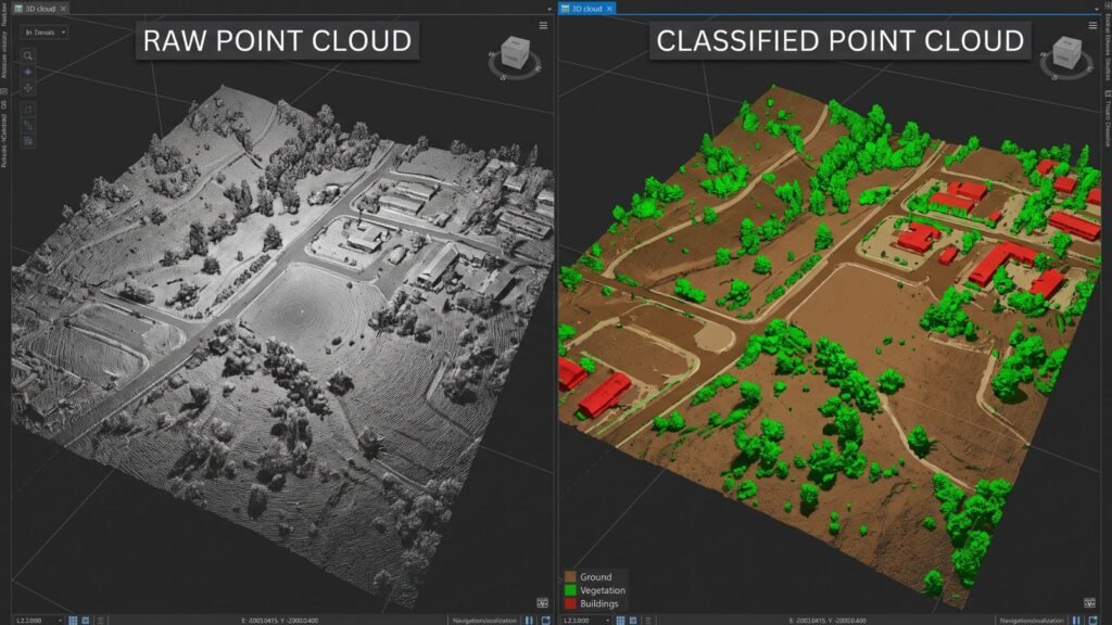
A useful cloud comes classified: each point has a class under the ASPRS standard. The most common are ground (2), low, medium and high vegetation (3 to 5), buildings (6) and water (9). Without classification, a reliable DTM cannot be generated.
Digital terrain model (DTM)
A continuous surface of the bare ground, without trees or buildings. It is delivered as a GeoTIFF raster or as a Civil 3D surface. It is the basis for road design, drainage and earthworks.
Digital surface model (DSM)
It includes everything above the ground: roofs, trees, towers. It is used for shadow studies, building heights and obstacles.
Contour lines
Lines that join points of equal elevation. They are generated from the DTM at the interval you request, for example every 0.5 m or every 1 m. They are delivered in DWG or DXF for AutoCAD and Civil 3D, or in SHP for GIS.

Orthomosaic
If the sensor carries a camera, a corrected, to-scale aerial image of the site is delivered. It is used to locate visible boundaries, roads and buildings.
Deliverables and formats
| Deliverable | Usual format | What it is for |
|---|---|---|
| Classified point cloud | LAS, LAZ | Basis of all other products |
| DTM | GeoTIFF, Civil 3D surface | Road design, drainage, earthworks |
| DSM | GeoTIFF | Heights, shadows, obstacles |
| Contour lines | DWG, DXF, SHP | Topographic plans |
| Orthomosaic | GeoTIFF, ECW | Visual reference of the site |
| Quality report | Accuracy achieved at check points |
How to review what the provider delivers
- Confirm the coordinate system: in the DR, WGS84 / UTM zone 19 North is commonly used, and for cadastral surveys the frame required by the Real Estate Registry.
- Open the cloud in a free viewer and check that no areas are missing.
- Verify that the ground class does not include roofs or treetops.
- Compare elevations with the check points in the report.
- Check that the contours do not cross or jump.
To understand how all of this is captured, see LiDAR in the Dominican Republic. A real project example is the LiDAR and GPS survey in Punta Cana. If you need these deliverables, contact surveying and geomatics companies in the directory and review how much a LiDAR survey costs.
Frequently asked questions
What is a point cloud?
A set of millions of points with 3D coordinates that represents the scanned terrain and objects.
What is the difference between a DTM and a DSM?
The DTM represents only the ground. The DSM includes buildings, trees and everything above the ground.
In what format is a LiDAR point cloud delivered?
In LAS or LAZ, its compressed version. Both are ASPRS standards.
At what interval are contour lines drawn?
It depends on the project. For design, every 0.5 m or every 1 m is typical.
What software opens a point cloud?
There are free viewers such as CloudCompare, and design programs such as Civil 3D, ReCap or QGIS.