Quick answer: LiDAR is a technology that measures terrain with laser pulses and generates millions of 3D points. In the Dominican Republic it is used with drones and aircraft to survey projects, roads, tourism developments and densely vegetated areas, because it captures the real ground even under trees.
LiDAR is no longer a lab technology. Today it is a standard tool for surveying land in the Dominican Republic, from farms in Higüey to road corridors and tourism projects in Punta Cana. This guide explains what it is, how it works, what it is used for in construction and land surveying, and what to consider before hiring it.
What is LiDAR?
LiDAR stands for Light Detection and Ranging. The sensor emits thousands of laser pulses per second and measures how long each pulse takes to return. From that time it calculates the exact distance to each point.
Combined with GNSS and an inertial measurement unit (IMU), each measurement becomes a point with X, Y and Z coordinates. The result is a point cloud: a 3D replica of the terrain and everything on it.
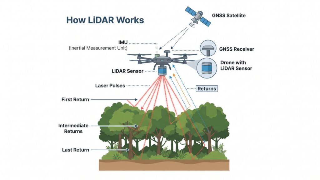
Why it “sees” the ground under vegetation
A laser pulse can have several returns. Part bounces off the leaves and part passes between them to the ground. Classifying the last returns yields the real terrain, something aerial photography cannot achieve over forest, mangrove or sugarcane.
Types of LiDAR used in the country
- Drone LiDAR (UAV): for farms, lots and projects of tens to hundreds of hectares.
- Airborne LiDAR (plane or helicopter): for provinces, watersheds or corridors many kilometers long.
- Terrestrial and mobile LiDAR: scanners on tripods, backpacks or vehicles for buildings, streets and works. It is explained in the guide to 3D laser scanning and Scan to BIM.
Uses of LiDAR in construction and infrastructure in the DR
Tourism and real estate projects
In Punta Cana, Bávaro and the east coast, LiDAR makes it possible to design developments, golf courses and drainage with the real relief. One example is the LiDAR and GPS survey of about 1,200 hectares in Punta Cana carried out by SECONPA.
Roads, energy and power lines
It is used to lay out road corridors, calculate earthworks and check clearances between conductors and vegetation on transmission lines.
Flood zones and risk management
High-resolution terrain models show where water flows. They are the basis of flood and stormwater drainage studies.
Land surveying and site planning
It helps understand a property’s relief before subdividing or developing it. For cadastral surveys, however, the methods required by the Real Estate Registry still apply: we explain it in LiDAR in land surveying and cadastral surveys.

LiDAR or photogrammetry: which to choose
Drone photogrammetry reconstructs the terrain from photos and is cheaper in open areas. LiDAR measures directly and works better with dense vegetation, cables or textureless surfaces. Many projects combine both. The full comparison is in LiDAR vs. drone photogrammetry.
What a LiDAR survey delivers
- Classified point cloud (LAS or LAZ format).
- Digital terrain model (DTM) and digital surface model (DSM).
- Contour lines in DWG or DXF.
- Orthomosaic, if the sensor carries a camera.
- Quality control report with the ground control points.
How to request and review each deliverable is detailed in point clouds, DTMs and contour lines.
Regulations that apply in the Dominican Republic
Drone flights (IDAC)
The Dominican Civil Aviation Institute (IDAC) regulates drones. Equipment over 4.4 pounds requires a permit, and drones are registered to obtain a registration number (El Día, 2023). There are restricted areas, such as airports, military installations and the National Palace.
Cadastral surveys (Real Estate Registry)
Provision DNMC-DT-2023-007 sets the methods for parcel surveys: static GNSS, GNSS RTK and total station, within the ITRF IGb08 frame. It does not include LiDAR or drones as a survey method.
Official geospatial data
IDERD publishes the country’s geospatial data. In addition, in March 2026 a market dialogue was held with the World Bank to generate DSMs, DTMs and orthoimagery with LiDAR for the entire national territory.
How much it costs and how to choose a provider
The price depends on area, vegetation, point density, access and deliverables. The factors and a checklist for comparing quotes are in how much a LiDAR survey costs.
Before hiring, ask for: the sensor and drone they will use, point density, number of control points, committed accuracy, delivery formats and the IDAC flight permit.
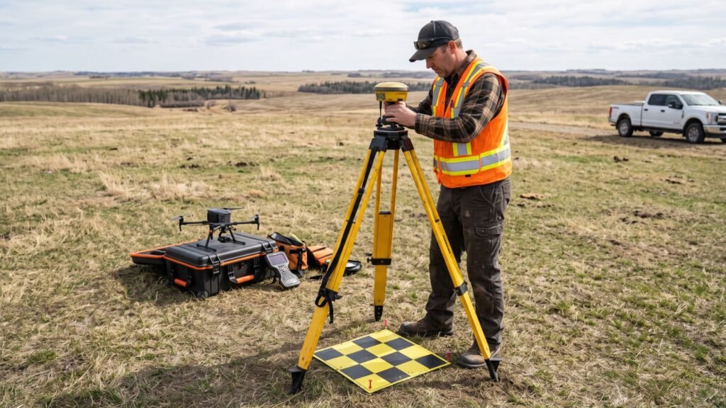
Find surveying and LiDAR companies in the ConstructHUBS directory. If your company offers these services, list it here.
Frequently asked questions
What is LiDAR in surveying?
A laser sensor that measures distances and generates a 3D point cloud of the terrain, from which terrain models and contour lines are obtained.
Does LiDAR penetrate vegetation?
It does not penetrate it, but some of its pulses pass between the leaves and reach the ground. That is why it captures the real terrain where photography only sees treetops.
How accurate is a drone LiDAR survey?
Usually within a few centimeters. It depends on the sensor, flight height and ground control points, so the accuracy should be written into the quote.
Is a permit needed to fly a LiDAR drone in the Dominican Republic?
Yes. IDAC requires a permit for drones over 4.4 pounds and prohibits flying in restricted areas without authorization.
Can LiDAR be used for a cadastral survey?
As support, yes. But provision DNMC-DT-2023-007 sets GNSS and total station as the parcel survey methods.
What is the difference between a DTM and a DSM?
The DTM is the bare ground only. The DSM includes everything on top: buildings, trees and structures.